


Some flurries or patchy freezing drizzle will be possible for parts of the area this morning. Areas of freezing drizzle or light snow are expected to increase from south to north across parts of eastern Nebraska and southwest Iowa late tonight. A Winter Storm Warning starts for counties along the Kansas border at 3 am tonight.
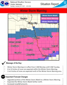
Winter Storm Warning has been issued for parts of eastern Nebraska and southwest Iowa for Monday into Monday night. The warning area is generally along and south of a line from David City to Omaha/Council Bluffs and Atlantic Iowa. Snow amounts of 6 to 12 inches are expected in the warned area, with the heaviest amounts south of a line from around Lincoln to Nebraska City and Red Oak. There is some uncertainty on the north edge of the system.
A Winter Storm Watch is in effect for parts of northeast Nebraska and west central Iowa, including Albion, Columbus, Norfolk, West Point, Fremont, Blair, Onawa and Harlan. Snow should decrease in coverage and intensity between 9 pm Monday and 3 am Tuesday. There is potential for 1 to 3 inches of snow with another system from late Tuesday afternoon through Tuesday night.
…WINTER STORM WARNING IN EFFECT FROM 6 AM MONDAY TO 3 AM CST TUESDAY…
Heavy snow expected. Total snow accumulations of 6 to 12 inches. The highest amounts are currently forecast south of a line from Seward and Lincoln to Nebraska City and Red Oak.
Travel will likely be very difficult. Areas of blowing snow could significantly reduce visibility. The hazardous conditions are expected to impact the morning and evening commute.
Precipitation could start as a mix of light snow and freezing drizzle early Monday morning.
If you must travel, keep an extra flashlight, food, and water in your vehicle in case of an emergency. The latest road conditions for the state you are calling from can be obtained by calling 5 1 1.


